Using LANDSAT to expand the historical record of phytoplankton blooms in Lake Erie
Abstract:
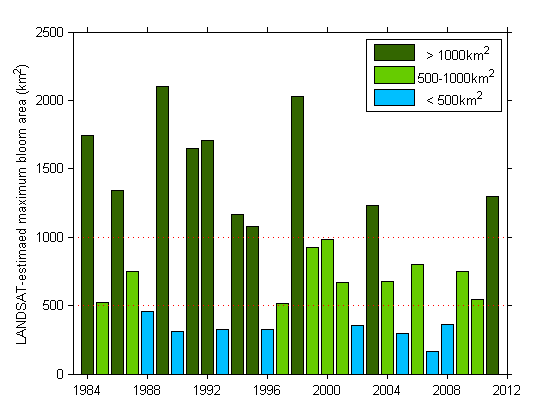
In this work, remotely-sensed observations of phytoplankton obtained using LANDSAT imagery are presented for 1984-2011. Several phytoplankton detection algorithms based on LANDSAT 5 imagery are evaluated during the period also covered by MERIS (2002-2011), which offers a relatively detailed assessment of bloom occurrence over the last decade. The best algorithm is then applied to historical LANDSAT data, and results are used to obtain new information about historical conditions and assess implications for developing improved models of bloom formation.
Estimates of historical bloom occurrence and bloom seasonality shed new light on the widely-held view that phosphorus controls and invasive mussels resulted in substantial bloom reductions in the early 1990s. The new estimated records are not consistent with limited in-situ phytoplankton measurements from that period, and provide additional information on bloom occurrence during years with little to no supporting literature. This work demonstrates the potential to unearth new insights about historical phytoplankton blooms in Lake Erie, as well as in freshwater lakes broadly, and is a step forward in supporting efforts to prepare for, and ultimately prevent, future blooms of harmful algae.