Tectonics Of Madhupur Tract and Lalmai Hill Ranges
Previously Published Material: Some parts of this works of Madhupur Tract resistivity survey data has been used in a poster of AGU Fall Meeting 2014, San Francisco, California, USA.
Abstract ID#: 34328
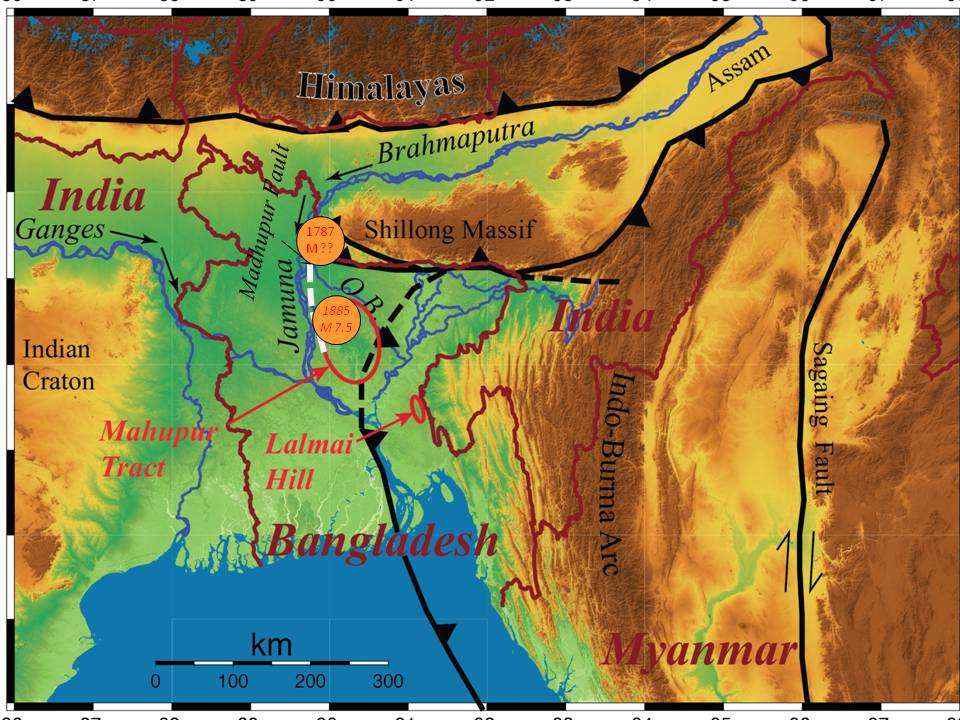
The north-south elongated Madhupur Tract, exposed at the central part of the country, is an uplifted interfluve of Pleistocene deposits in Bangladesh. Its upper part is the Madhupur Clay with the top silty fine sand layer underlain by Dupi Tila sandstone in the lower part. The en echelonlinear segments on its western margin are known as Madhupur fault. The Bengal earthquake of magnitude M7 is interpreted to have occurred on this fault (see figure). The 1787 earthquake north of the Madhupur tract induced an avulsion of the Brahmaputra River from its Old Brahmaputra course east of the Mudhupur to its present Jamuna River course flowing parallel to the western edge of the tract.
The Lalmai Hill is northsouth elongated anticline, 17 km long and 12.4 km wide hill. The hill is the westernmost exposed anticline of the Indo-Burma foldbelt, the subaerial accretionary prism of the subduction of India beneath the Burma microplate. In the exposed hill, the capping are reddishbrown deposits, also called the Madhupur Clay of Pleistocene age, underlain by the Dupi Tila Formation of PlioPleistocene age. The boundary between Madhupur Clay and Dupi Tila Formation is characterized by a gravel bed, called Quartz Chalcedony Gravel Bed.
Madhupur Tract and Lalamai Hill Ranges both expose the same Pleistocene deposits. Most parts of Holocene strata are contaminated with arsenic, while the Pleistocene is low arsenic. The LGMP (Last Glacial Maximum Palaeosol) clay often acts as a barrier to flow arsenic in aquifers. We will present additional data from buried sections Lalmai Hill to establish whether the LGMP clay is continuous of breached across the truncated parts of the anticline. Already collected data from the Madhupur Tract shows an abrupt edge of the Holocene strata against the Madhupur Tract at the linear features. This research will search the best correlation between the two upland areas in lithology, tectonics, structural settings and relative age difference of their uplift.